

If you’re looking for a spectacular, but quiet fell walk - the kind where you rarely see a soul, even in August - then Lingmoor Fell is for you. This trail takes you over both Side Pike and Lingmoor Fell to create a truly spectacular circuit.
As well as incredible views, you’ll also get to pass through one of the Lake District’s most fun rock formations: ‘the squeeze’, aka ‘fat man’s agony’, a narrow slit on the side of a cliff which looks particularly daring in photos.
To top it all off you can finish your walk with a refreshing swim in the gorgeous Blea Tarn. Here’s everything you need to know about the Lingmoor Fell circular walk.
The Lingmoor Fell circular walk
The stats
Distance: 3.7 miles (6km) loop
Elevation gain: 370m
Difficulty: Moderate
Summary: This trail does have two notable climbs, but as they are relatively far apart, it’s not as tiring as if you were climbing all the elevation in one go. When walked clockwise (as described below) there are a couple of steep sections on the descent, but a large part of it is gentle.
The terrain can be rocky, with some very minor scrambling when ascending Side Pike and Lingmoor Fell. When the rock is dry this is easy and straightforward and there is no exposure. I wouldn’t advise this walk in the rain, mainly because I think parts of the descent could become slippery.
The section known as ‘the squeeze’ is not really exposed, despite how some camera angles make it look.
There is little to no signage along the trail, so you’ll want to download an offline map, or screenshot our directions below.
Starting the trail
From the Blea Tarn car park (full details below) the walk heads over the road and through the gate. You’ll see the stunning Blea Tarn immediately, and follow the flat gravel path that runs around the tarn towards the wood.
You’ll reach the wood after 250m and the flat easy trail continues.


After another 100m you’ll see a turning on the right and take it. This path soon leaves the wood and the side of Blea Tarn and heads into an open landscape, surrounded by fells.

Although there are some very gentle uphill sections, the majority of this first bit of the walk is flat. You’ll come to a gate just under a mile (1.4km) from the car park.
From here you get some great views out to Bowfell and one of our favourite waterfalls in the Lake District, Whorneyside Force.

Climbing Side Pike
After passing through the gate you take a left, quickly followed by a right and then the gravel path will begin to curve left. The climb to the top of Side Pike is a mix of a good gravel path and intermittent rocky sections.
These rocky sections are sometimes straightforward steps up the rock and occasionally require the use of hands as well. All the rock was good and grippy when dry and it’s not exposed.


The views keep getting better and better, both over Blea Tarn and the Langdale Pikes. The route up is quite obvious, although there are sometimes several paths you could choose from.
At the 1.8km mark the path takes you to a little wall, which you can climb over to continue heading uphill.

Roughly 150m later you’ll come out at a large flat area marked with a huge cairn. The views are fantastic from here and if you’re walking in August, you’ll start to get some lovely patches of bright purple heather.

Reaching the top of Side Pike
Just 200m beyond the cairn (still climbing) you’ll reach a junction. Heading left will take you to the top of Side Pike and right would continue the circuit, towards Lingmoor Fell.
The top of Side Pike is just a 100m (each way) detour and well worth it for the expansive views.

You’re surrounded by rugged fells and Blea Tarn looks satisfying small, marking how far you’ve already come. The heather was wonderful up here and really added to the already phenomenal views.
We were so surprised that despite walking on a warm day in August, we hadn’t seen a soul since leaving Blea Tarn.

The only slight downside was that we happened to walk when there was an explosion of flying ants around, though even that didn’t put me off lingering to take in the views.

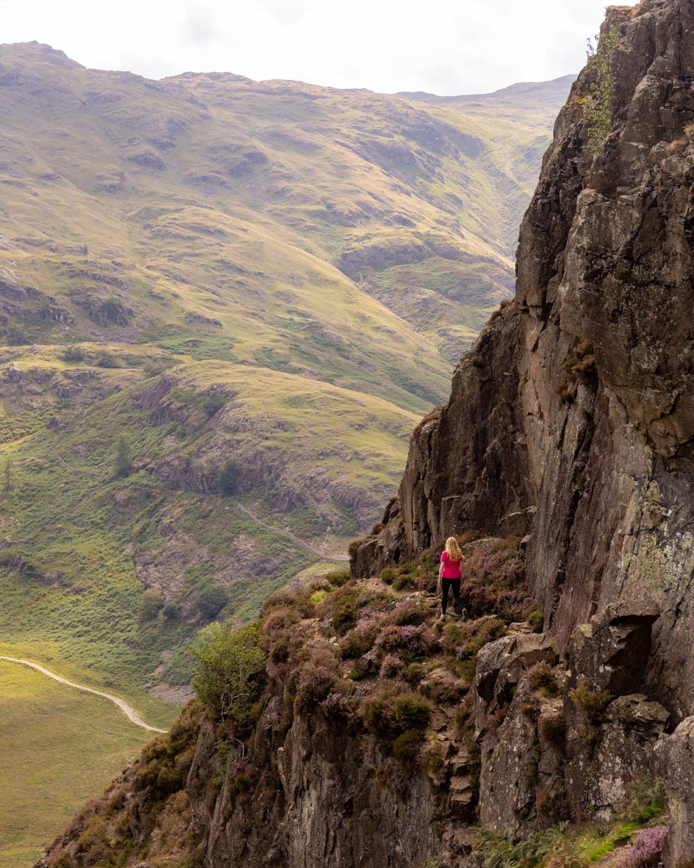
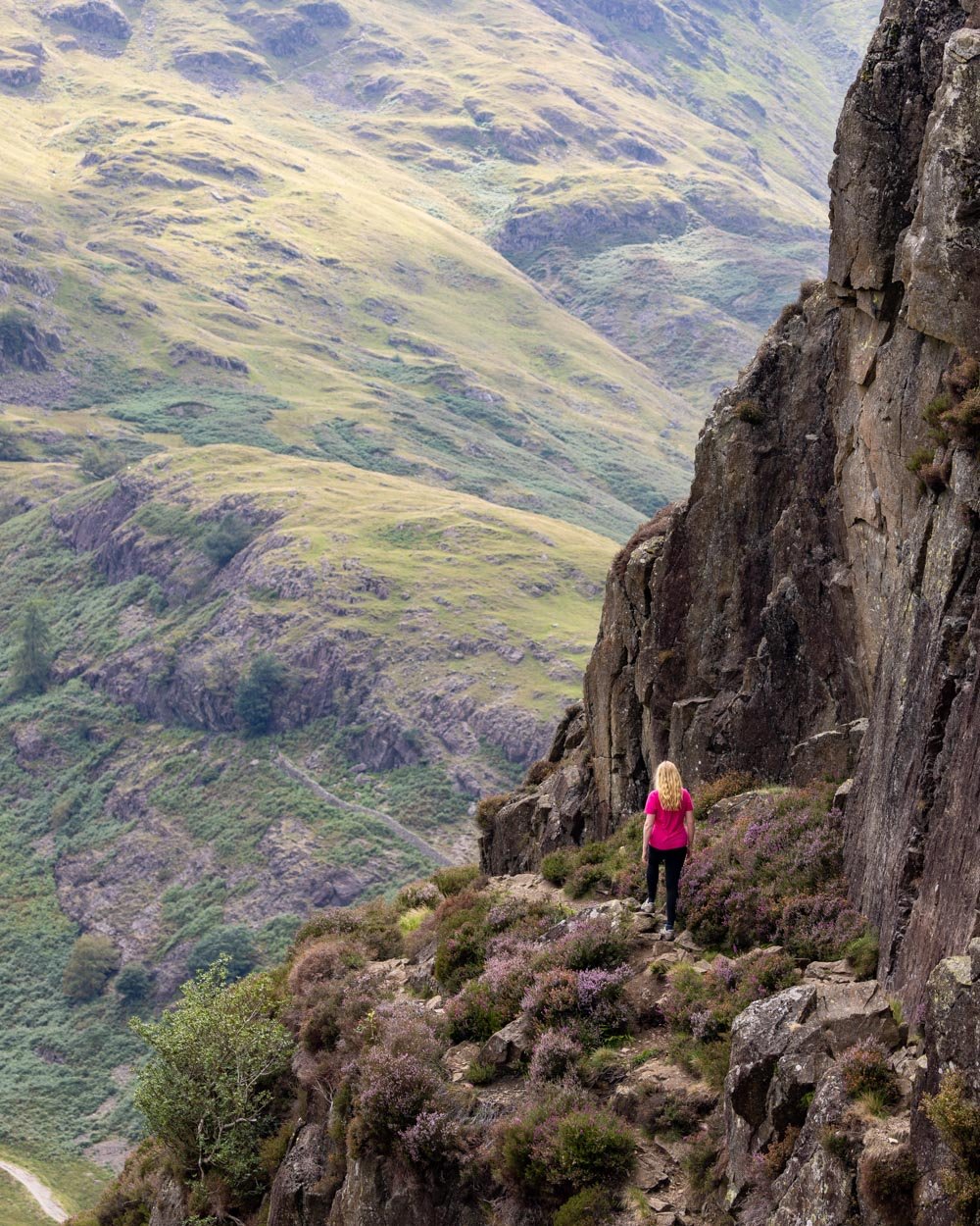
Descending Side Pike to ‘the squeeze’
From Side Pike you head back to the trail junction and then take the path on the left. The descent has a rocky path in places, but it’s not loose rock and wasn’t slippery (when dry).

After just 150m from the junction you’ll arrive at ‘fat man’s agony’ also known as ‘the squeeze’. The few metres before you reach this point are on a narrow path with a bit of a drop off to one side, but it’s not jelly legs narrow or exposed, unless you suffer from vertigo.
The rock formation known as ‘fat man’s agony’ is a narrow slit between the cliff walls that you must pass through to continue the trail.


Most people will have to turn on their side and it’s easier if you remove your backpack. The footing is ever so slightly awkward when you exit, but overall it’s a fun little bit of the track. Clever camera angles can make it look very exposed, but the rock is shielding you from the drop, so it doesn’t feel like you are on a cliff edge.

Climbing Lingmoor Fell
From ‘fat man’s agony’ the path hugs the cliff and climbs briefly uphill before you continue descending 150m later.

There’s a short section of rocky gully before it becomes a good gravel path, leading to a gate. From here the ascent to the top of Lingmoor Fell begins.
There’s another gravel path which is gentle for a while, before it steepens and reaches a cairn at the 3.1km mark.
After this you’ll cross over a stile and from here you’ll have a mix of a normal path and some short rocky sections.


Sometimes there are routes which you could use that avoid the rocky bits, but the little scrambles are the most direct route.

This lasts for about 300m before you reach a standard trail that will take you all the way to the top of Lingmoor Fell. Some parts are quite steep, but there are gentler bits in-between.

The heather is prolific along this part of the walk and it’s easy to see how Lingmoor Fell got its name, ‘heather covered’ in the old Norse language.

The views are also great and you’ll see a small tarn in amongst the heather, as well as the beautiful fell views, which are a constant on this walk.
You reach the top of Lingmoor Fell 4.1km into the trail and it’s a good spot to sit and take it all in.


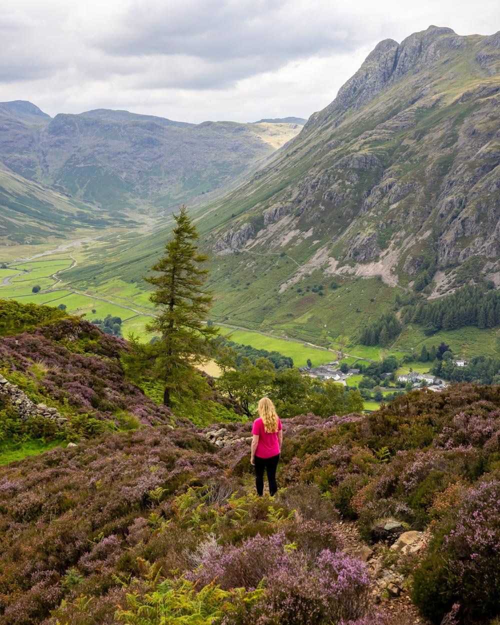
The descent
The descent from Lingmoor Fell heads over the stile you can see to the right when on the summit. It begins as an easy grassy path before hitting a 90m steep rocky patch.
It gets gentler again after this. Just after the rocky section the ground can get a bit boggy and you’ll see a stile.

Cross over the stile and follow the gentle grassy track. You’ll see a cairn 100m after crossing the stile. Another 100m beyond this you will start to get a mix of track conditions.
There are some steep bits, including short sections with loose rock, though there are steps and better paths inbetween to break up the steeper bits.


After 750m of mixed terrain you’ll come out at a grassy area and see the road ahead of you. You’ll reach it 50m later and turn left.
The last 450m are along the road, but it’s generally very quiet and mainly flat.
Finishing the walk with wild swimming at Blea Tarn
There’s no better way to end the walk than with a dip in the cool water of Blea Tarn. It’s a stunning spot, with sensational views of the Langdale Pikes. It feels much more remote than it truly is and it’s only an additional 220m (each way) from the car park to get to the water’s edge, so it’s not really any extra effort.
Although it’s worth noting the last few metres to the tarn are really boggy and try as we might, we couldn’t find a way of avoiding it. Best to just take your shoes off and succumb to the squelch before washing it off in the tarn. Try and access the pool somewhere between the small ‘beach’ on the right side of the tarn, and the first set of rocks.

We accessed it more towards the middle and it’s full of banana skin style slippery rocks, which you do not want to be walking over, especially as it’s so shallow at first. Luckily we found the better way to exit the pool, which had virtually no rocks and was very easy.
Parking for the Lingmoor Fell walk
The trail begins at the Blea Tarn car park in Langdale, postcode LA22 9JU. The car park is run by the National Trust and is free for members and otherwise £5 for 2 hours, £7 for 4 hours or £8.50 to park all day.
We counted room for around 21 cars to park here if everyone parks sensibly, so it can fill up on sunny days, when people come to swim in the tarn. We started our walk around 2pm in August and got the last spot, so much earlier or a touch later might be better.
There are no toilets or other facilities at the car park or along the trail.
Getting to the trailhead
The last part of the journey to the Blea Tarn car park is on the Wrynose Pass, this is a steep single track road. You don’t have to spend too long on this road, but it’s worth going very slowly as passing is difficult.
The car park is located just over a 20 minute drive from Ambleside, the same from Coniston and 50 minutes from Keswick.
As far as we could see there was no option to get directly to this spot via public transport, though you could use a completely different route on a much longer walk.
This post may contain affiliate links, meaning at no additional cost to you, we will earn a small commission if you click through and decide to make a purchase. This helps towards the costs of running our website. Thanks for your support.


