

The top of a rock as ginormous as the Bowder Stone would normally be the domain of rock climbers and boulderers alone. Happily for those of us that don’t fit into either of those categories, a staircase has been installed that allows anyone to stand on its lofty summit - which has been a popular thing to do since Victorian times! Back in the day it was a wooden ladder, which might have put some people off, but today it’s a sturdy metal staircase with handrails!
If you want to extend your time in the Borrowdale Valley there are a couple of good walks that begin at the Bowder Stone car park, and we’re detailing the easiest option in our trail notes below.
Here’s everything you need to know about visiting the Bowder Stone.

Visiting the Bowder Stone
The parking options
The official Bowder Stone car park (postcode CA12 5XA) is run by the National Trust and there’s a fairly hefty parking fee if you’re not a member. The current fees are: £5 for 2 hours, £7 for 4 hours or £8 for all day parking (if you buy all day parking you can use it in any of the car parks run by the National Trust in Borrowdale and Buttermere that same day, which makes it better value).
Although you can easily visit the stone and do the circuit walk we’re describing below in two hours, it’s still relatively expensive.
We had a membership card, so we did park there, but if you don’t, we did notice a lay-by with enough room for around two cars a little way before the car park when driving in from Keswick.
Although you will see a couple of spaces by the bus stop at the trailhead to the Bowder Stone, these are disabled parking spots and the official car park is up the gravel road above the bus stop.
Another alternative is to start the walk to the Bowder Stone from the other direction using the public footpath. There is a bigger lay-by at the start of the footpath, which had room for a few more cars, you can find it here. Although we haven’t done the walk from this start point, we estimate it’s a similar length.
The Bowder Stone Walk
Distance: 0.35 miles (550m) each way
Elevation gain: Flat
Difficulty: Very easy
From the official car park you head briefly back down the road you drove up and then take the little staircase on the left. You’ll then keep left at the bus stop area and follow the footpath, which is signposted as the Bowder Stone.

It’s a good gravel track and nicely shaded by the woodland on either side of it.
As you head along the path you’ll pass some beautiful old oak trees amongst the dense bracken.

The trail heads very gradually up and then downhill, but it’s gentle. You’ll reach the Bowder Stone 600 yards (550m) after leaving the car park, which took us 10 minutes at a leisurely pace, with lots of photo stops.


Climbing the Bowder Stone
The Bowder Stone is huge and though the surrounding area is littered with smaller rocks, nothing even comes close to this 2000 ton giant.
How it got here is still a mystery, with some people believing it was left over from a melting glacier and others believing it could have fallen from the fells above. Either way it’s very striking.

The woodland to the left of the stone is also home to a lot of gnarled old oaks which gave us mini Wistman’s Wood vibes. There’s also a cottage partially obscured by woodland and the combination makes for an atmospheric setting.


When it comes to climbing to the top of the stone, it’s very easy with the new metal staircase.
It’s steep but sturdy and there are handrails all the way to the top.

Once you’re up there you can walk across the top of the boulder and enjoy the views out to distant fells.
As Lake District views go, it’s not necessarily going to blow you away, but it’s pretty, with the tops of the mountains peeping out above the tree line.

The circuit walk beyond the stone
If you want to do a longer walk in the area you have a few options leaving from the Bowder Stone car park.
Most people will opt to head up King’s How Fell, but we were visiting after many days torrential rain and didn’t want to take on any rocky terrain, which would likely be slippery.
Instead we opted to complete a circuit walk beneath the fells, which turned out to be a lovely little trail to escape the crowds. Despite visiting in the summer holidays, we never saw a soul on the walk and enjoyed some lovely views looking up at the craggy fells above.
It does involve a bit of road walking to complete the circuit, though there’s a dedicated footpath beside the road for all but a few steps, so you don’t have to worry about traffic.

The Bowder Stone circuit walk
The stats
Distance: 2.7 miles (including the return walk to the Bowder Stone)
Elevation gain: 140m
Difficulty: Easy, but not flat

The trail
From the Bowder Stone car park upper level, you look for a narrow, slightly overgrown path on the left (heading north). There are actually two paths on the left, we took the one on the far left.
The gravel trail is very narrow, made even more so by the bracken trying to reclaim the path, something which is a recurrent theme throughout the walk.
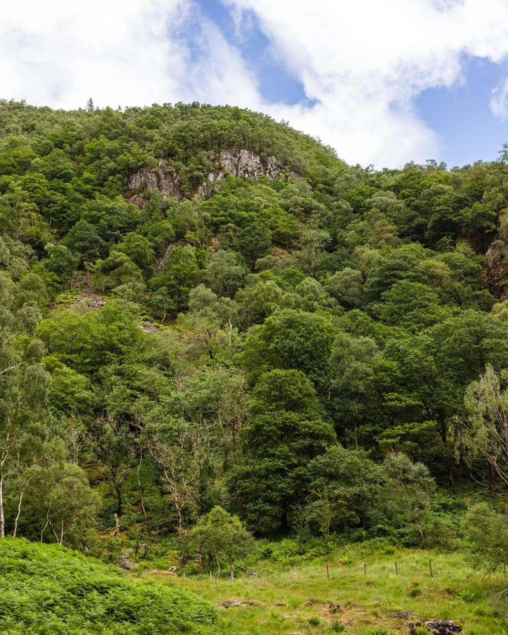
The views are lovely from the off though, with the tops of the craggy cliffs peeking out amongst the densely forested walls.

There’s a small stream crossing after 100m, but there are rocks to use as stepping stones and it was easy even after the huge recent rainfall.
The path is mainly flat and continues to have great views of Castle Crag and the surrounding fells. It has a slightly forgotten air, which must be down to the lack of people around and the fact it’s slightly overgrown.

That feeling increases when at the 300m mark you’ll pass through an area with bracken that was nearly as tall as me!
You can push through easily enough, but you need to watch your step as you can’t really see what’s on the ground in places.

Just past the giant bracken the track begins heading uphill. It’s steepish and lasts for a few hundred metres, but the views get even better. After you’ve been walking for 750m you’ll pass through a gate and continue along the obvious path.
It felt really different to any other walk we’ve done in the Lake District, it’s hard to describe why, but the scenery reminded us more of our favourite place in Australia, the Blue Mountains than the Lakes!


The riverside section
At the 900m mark you’ll reach a fork and bear left, heading towards the wall and gate. Roughly 100m later you’ll cross another small creek (again it’s easy) and the track takes you downhill.

You’ll join a riverside path, if you take the higher route there are a couple of very short rocky bits to scramble down, but the lower route is smoother - if you can spot it because the higher route is the more obvious one.
As you bear left alongside the river, the path can become a bit waterlogged after heavy rain - nothing that totally floods your boots, but not far off.

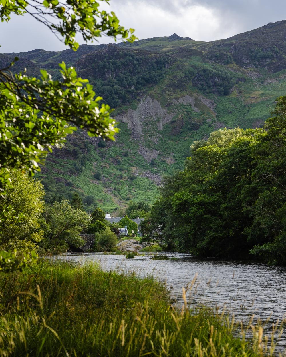
It’s a pretty trail though and the river was crystal clear despite the high rainfall, which was a marked difference to others in the area at that time!
A few hundred metres along the riverside path and you’ll get a lovely view of Derwentwater. However, the path can be a bit boggy beyond this point, so although the waterlogged trail before may not have flooded your boots, this next section might!

It’s hard to say whether it was significantly worse when we did it as there has been so much rain, but I suspect it would be somewhat boggy year round.
It’s intermittent for the next hundred metres and you can often avoid it, so it’s not too bad overall and the view to the lake and fells is really lovely. You’ll also pass a few farmhouses which provide more quintessential Lake District scenes.


Finishing the loop
Just over 1 mile (1.6km) into the walk you’ll reach a gravel path which leads towards the road.
It’s a quiet country lane at first and you’ll soon pass The Leathes Head, which advertises you can pop in for tea and coffee, or maybe something stronger. Just beyond the hotel you’ll reach the main road through Borrowdale and turn left.
There’s a footpath running alongside the road and this remains for all but a tiny section right the way to the car park, so there’s no dodging cars involved.

After 200m you’ll see a path leading down to the river which you can take and it keeps the road a touch further away.
It doesn’t take you all the way back to the car park, but it lasts for around 300m, at which point you’ll pop out onto the road and then pick up the footpath again.

You then follow the same path for the next half a mile (750m) before arriving back at the car park.
Getting to the Bowder Stone
The Bowder Stone is located in the Borrowdale Valley, just under a 15 minute drive from Keswick and 45 minutes from Ambleside. All the parking details are at the top of this article.
You can also get the 77A or 78 Borrowdale bus from Booths in Keswick right to the Bowder Stone trailhead. Just hop off at the stop called “Kings How” and this takes around 20 minutes from Keswick.
This post may contain affiliate links, meaning at no additional cost to you, we will earn a small commission if you click through and decide to make a purchase. This helps towards the costs of running our website. Thanks for your support.


